Lyons flood: my diary
Wednesday evening (Sept. 11) it begins raining. Steady and hard, but not bucketing down. Sometime around midnight John gets up and checks the rain. The backyard is full of water, enough so that it backs up to the house and finds a couple pipe-holes into the basement. He sets up a sump pump in the backyard, and collects dripping water in the basement. At the worst, he was carrying a 5 gallon bucket up from the basement every 5 minutes.
Meanwhile, my iPhone keeps giving alerts from the CU Boulder. A flood alert is in effect for the Boulder campus, with everyone advised to seek higher ground. Campus is closed for the day by about 4 a.m.
We are not too worried, since we are not right next to a river and the basement flooding is manageable.
About 4:30 a.m., I hear the neighbor's truck start up. Uh oh, the Little Thompson could be flooding. I watch as he drives to the river and comes right back. The river must have flooded the road. Then he goes out towards the main road. I watch and sigh in relief as he crosses the area over the culvert that could flood, the one between us and the mailboxes.
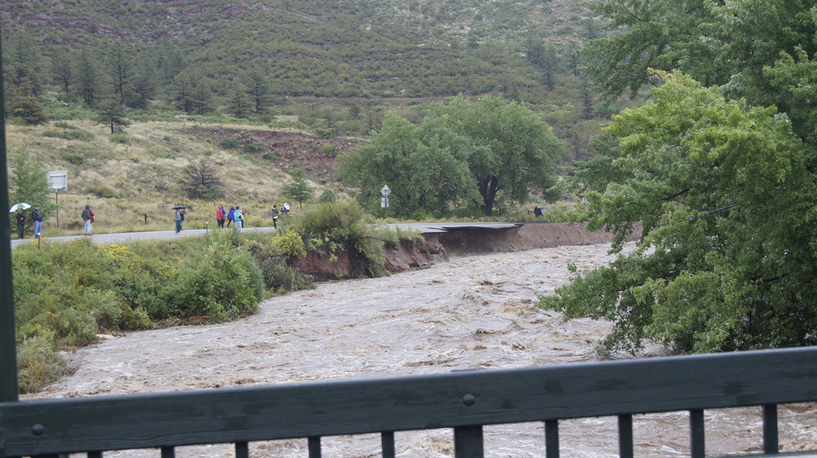
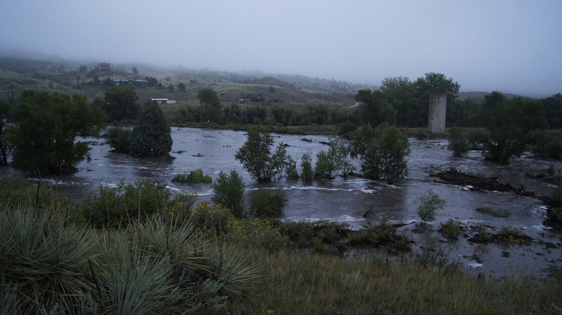
As soon as it is light, I walk down to the Little Thompson. You cannot believe how huge it was. The road is washed out, cutting off the fifty or so homes back there.
We still have power and phones Thursday morning. The news for Boulder looks bad. But Lyons is worse. The rivers that run through town (the St. Vrains) have breached their banks and all of the bridges in town.
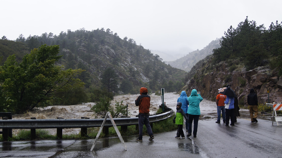
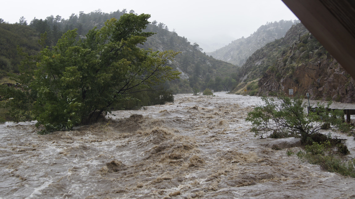
Residents of our immediate area gather informally at various informal points and news is transferred. We learn that the St. Vrain has flooded the highway at the Rainbow Bridge, the bridge from Blue Mtn Road (hwy 71) to the Apple Valley Road. John and I drive down about noon, and I posted photos on my blog.
It rains all day Thursday. We see no helicopters or rescue vehicles. By 3 p.m. on Thursday we lose power, and by 8 p.m. we lose our landline (and DSL, of course). There has never been cell phone service in the valley, so we are totally cut off from easy communication with the rest of the world. Our community meetings are a sanity saver.
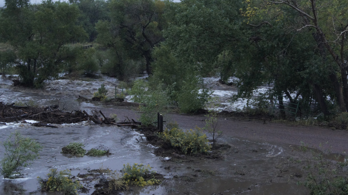
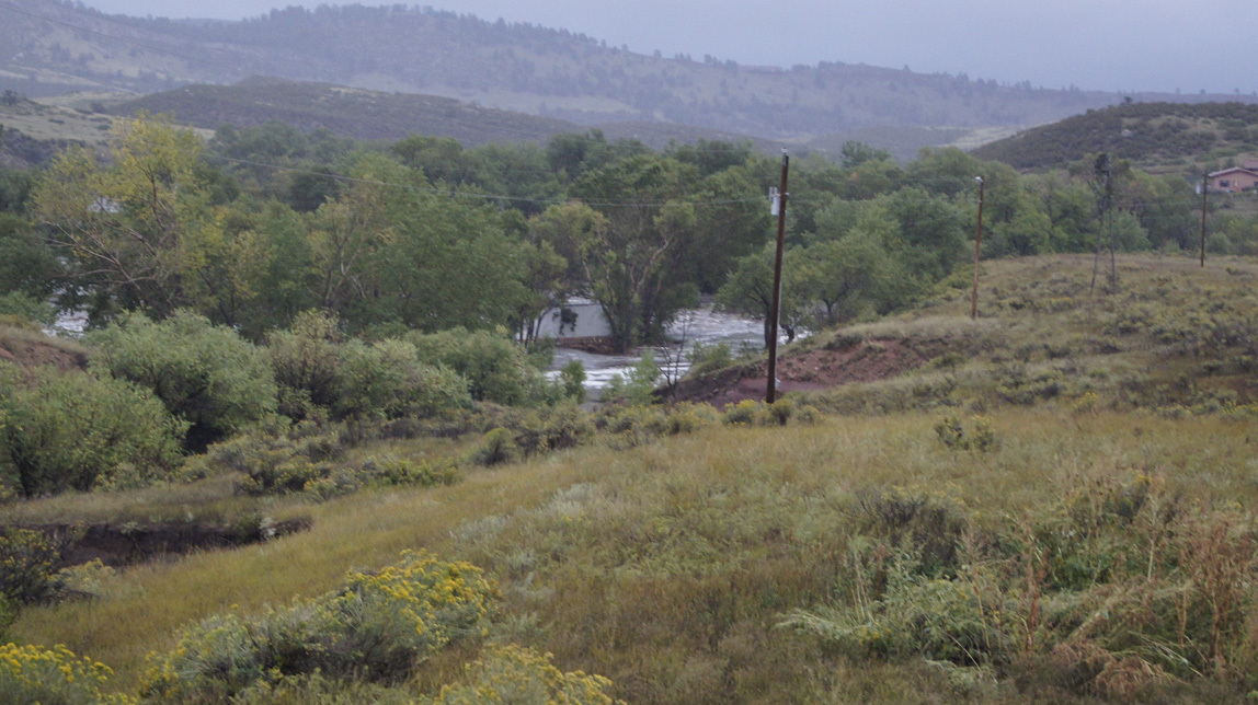
We watch the Little Thompson on Thursday. Huge trees, stripped of limbs, float down the river like twigs. A semi-trailer is stuck for awhile against the trees below the bridge. Propane tanks, barrels, debris are all swept down our little river. It's simply incredible. I took photos and movies and will upload when I get a chance.
We have a neighbor with excavation equipment and others with equipment are also trapped in our little area and also the isolated area across the Little Thompson. They begin re-routing the Little Thompson back under the bridge, a project that takes until late Monday afternoon to complete.
On Friday, 3 p.m., our community meets formally at the mailboxes. This becomes our daily routine: community meetings at 10 a.m. and 4 p.m. to share news and critical resources. Volunteer fire department guys live on both sides of the Little Thompson and are in radio communication with each other and the authorities in Lyons; this news is communicated at the meetings.
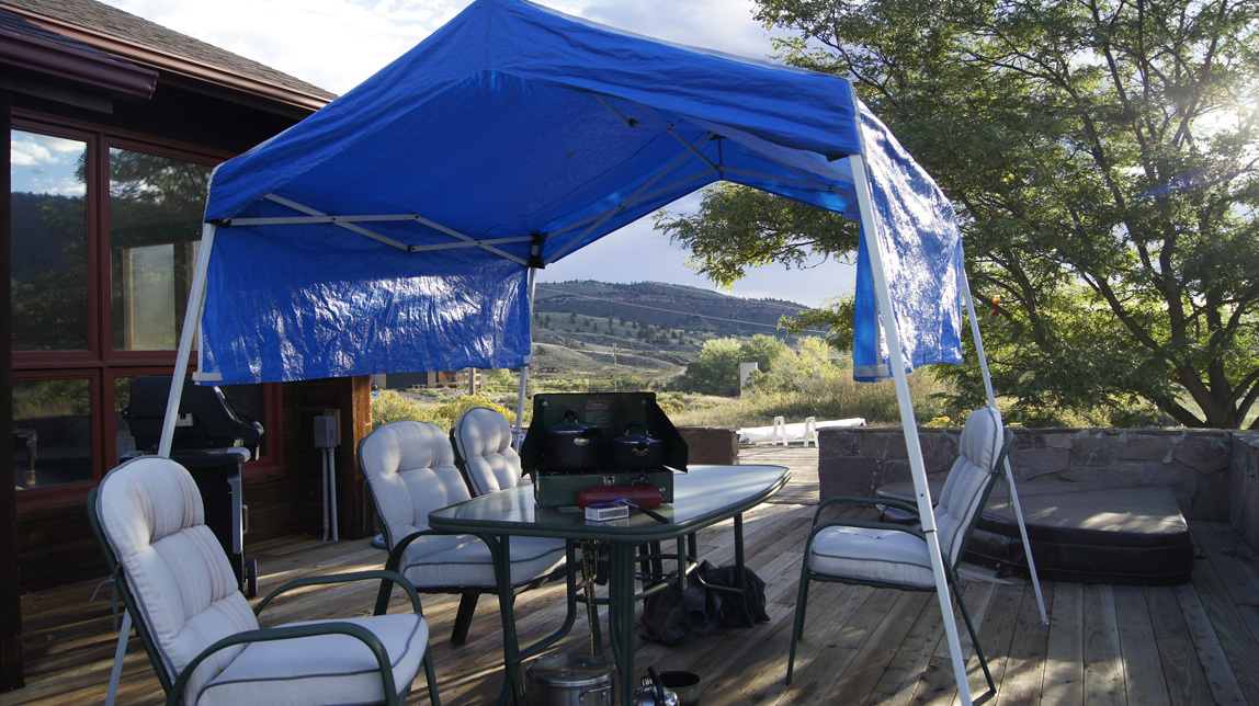
Friday we settle in to camping at our house. We have a generator - it is old but it works. Our house is all-electric (we do not have propane). We can plug in about 4 big extension cords at a time, enough to keep the kitchen refrigerator and the basement freezer chilled, run the microwave or toaster oven, a light or two, charge my laptop and phone and devices, and power the TV. But we run the generator sparingly, because it's noisy and we don't have to have constant power. It's warm enough, so we don't have to heat the house. I am a packrat, and figure that I have enough food to last us at least 3 weeks.
For water, we cannot move water out of our well/cisterns (takes electricity), but we do have 55 gallon drums of drinking water in the basement, and an above-ground swimming pool full of water. We have the gas grill and a camping stove. We bucket water to the toilets, and heat water on the camping stove for bucket showers. They feel wonderful!
Most homes in our area are about like ours. We live in a big valley with most homes sitting on 10-35 acres. Our homes are self-sufficient, and we are used to power outages. Many have generators, we all rely on our individual septic systems rather than a public sewer system. None of us are on city water, so we are used to finding water by alternative sources.
We are camping, but camping with use of the shelter and supplies in our own home.
Friday skies cleared enough for helicopters to come to the valley. First, Red Cross and National Guard. Once an expensive private helicopter flew over, we think it was probably governor Hickenlooper.
We learn that hwy 36 to Lyons is destroyed at the Stone Mtn hotel. Up towards Estes, it's destroyed at the Longmont Dam road. At the end of Apple Valley, the bridge is under water, but the structure of the bridge has held. That is our hope.
On Saturday, FEMA trucks come into the valley. They come over the quarry road. Now, John and I have never even been up there. But there is a road up the mountain that the sandstone quarry trucks use to come down to our valley, and there is also a road from the quarry out through Stone Canyon to Lyons. This is the access they use today, as the Apple Valley bridge road is "fragile". We are offered evacuation, but decide to stay. The government guy who came to our house was very friendly and quite frankly, I think he was glad that we were totally self-sufficient: one less family that they had to help.
By Sunday, the road/bridge through Apple Valley to Lyons and then on to Longmont is passable. Our community is allowed to use 2-3 trucks a day to make a run out for essentials. Gas for the generator is our essential need. At community meetings, people bring eggs and any other extras that they have. Everyone speaks up their needs: hay for horses, bread, milk, water, etc. Lots of people back here have freezers full of game meat or beef. A board lists local people who are medical workers and vets, as well as where to find a phone or cell service. Josh Buster, who runs the quarry, tells us that we can go up the quarry road and use the wi fi and phone access up there. There is also a spring for drinking water.
Today (Sunday), if we really wanted or needed to, we could drive our car out through the Apple Valley road. But we could not come home.
We stay in our community. It's a good feeling, knowing that we are a community.
Here is the sad damage.
Tom's house, the original X Bar Seven homestead house (we still always call it "Brownings"), flooded Thursday night. Half of the house is gone, and he and his partner were stranded on an island formed by the Little Thompson. He signaled us for a helicopter on Friday morning; his partner has medical issues and needs to get out.
Four or five other homes further down the Little Thompson were destroyed. At a community meeting, I talked with a woman I know from pilates: her home was destroyed. The original Buster home was flooded.
Shelley's Cottages are gone. Probably other cottages and homes up the way towards Estes are gone too.
The town of Lyons is completely evacuated, except for a few hardy people who are willing to live without city services (they have to boil drinking water, and have no flushing toilets). The flood damaged or destroyed all of the Lyons homes that were on the rivers. The bridge at the junction of hwy 36 and hwy 66 is probably destroyed. For a time on Thursday/Friday, all roads out of Lyons were under 4 feet of water. No help got in on Thursday at all. The road between the U Pump It and the Black Bear flooded and is partly destroyed. Both bridges to the high school are destroyed. The St. Vrain Market had a foot of water, although the Steamboat Mtn store and the Stone Cup area survived with just some water damage. The new homes by the high school were isolated for several days, no one could get to them because of the flooding rivers. There were other isolated areas; we shall learn all of the stories later. Lyons (the town) was evacuated by big trucks that could get through 4 feet of water and also by helicopter.
It will take 30 days, minimum, for Lyons to have all services restored. Both schools are closed, obviously.
Pinewood Springs was cut off from everything. It took until Monday for the FEMA helicopters to airlift residents out.
All road access (except Trail Ridge) to Estes Park has been destroyed.
Update, 11:00 a.m. Tuesday. Just back from a community meeting. For the first time, people from across the river can attend.
FEMA has designated our area "uninhabitable". Well that's quite plainly incorrect! But since that is our status, we still cannot get resident passes to egress out through Lyons. They want as little traffic as possible to go that way, because each time a car passes, they have to shut down road work. Our community is sending volunteers to man a check-point at the Rainbow Bridge to prevent anyone without dire need from trying to drive out and disrupt the reconstruction process. We hope that within several days, the road will be fixed enough to allow us to go out and in with resident passes. What is working to our benefit is that the highway from Lyons to Estes Park - the road we use to get anywhere - is a major route, so the government is putting tons of resources to work on repairing the infrastructure of our roads and of Lyons.
That's it, to date!
Movie of Little Thompson, September 12, 2013.
Photo taken from our upstairs balcony about dusk on September 12. Right in the middle of the swollen river you can see the trailer of a semi truck lodged in some trees. The next morning, it was gone . . . somewhere downriver.
Movie of Little Thompson, September 13, 2013.
Camping out on our deck.
Next Lyons flood entry
First Lyons flood entry
Meanwhile, my iPhone keeps giving alerts from the CU Boulder. A flood alert is in effect for the Boulder campus, with everyone advised to seek higher ground. Campus is closed for the day by about 4 a.m.
We are not too worried, since we are not right next to a river and the basement flooding is manageable.
About 4:30 a.m., I hear the neighbor's truck start up. Uh oh, the Little Thompson could be flooding. I watch as he drives to the river and comes right back. The river must have flooded the road. Then he goes out towards the main road. I watch and sigh in relief as he crosses the area over the culvert that could flood, the one between us and the mailboxes.
As soon as it is light, I walk down to the Little Thompson. You cannot believe how huge it was. The road is washed out, cutting off the fifty or so homes back there.
We still have power and phones Thursday morning. The news for Boulder looks bad. But Lyons is worse. The rivers that run through town (the St. Vrains) have breached their banks and all of the bridges in town.
Residents of our immediate area gather informally at various informal points and news is transferred. We learn that the St. Vrain has flooded the highway at the Rainbow Bridge, the bridge from Blue Mtn Road (hwy 71) to the Apple Valley Road. John and I drive down about noon, and I posted photos on my blog.
It rains all day Thursday. We see no helicopters or rescue vehicles. By 3 p.m. on Thursday we lose power, and by 8 p.m. we lose our landline (and DSL, of course). There has never been cell phone service in the valley, so we are totally cut off from easy communication with the rest of the world. Our community meetings are a sanity saver.
We watch the Little Thompson on Thursday. Huge trees, stripped of limbs, float down the river like twigs. A semi-trailer is stuck for awhile against the trees below the bridge. Propane tanks, barrels, debris are all swept down our little river. It's simply incredible. I took photos and movies and will upload when I get a chance.
We have a neighbor with excavation equipment and others with equipment are also trapped in our little area and also the isolated area across the Little Thompson. They begin re-routing the Little Thompson back under the bridge, a project that takes until late Monday afternoon to complete.
On Friday, 3 p.m., our community meets formally at the mailboxes. This becomes our daily routine: community meetings at 10 a.m. and 4 p.m. to share news and critical resources. Volunteer fire department guys live on both sides of the Little Thompson and are in radio communication with each other and the authorities in Lyons; this news is communicated at the meetings.
Friday we settle in to camping at our house. We have a generator - it is old but it works. Our house is all-electric (we do not have propane). We can plug in about 4 big extension cords at a time, enough to keep the kitchen refrigerator and the basement freezer chilled, run the microwave or toaster oven, a light or two, charge my laptop and phone and devices, and power the TV. But we run the generator sparingly, because it's noisy and we don't have to have constant power. It's warm enough, so we don't have to heat the house. I am a packrat, and figure that I have enough food to last us at least 3 weeks.
For water, we cannot move water out of our well/cisterns (takes electricity), but we do have 55 gallon drums of drinking water in the basement, and an above-ground swimming pool full of water. We have the gas grill and a camping stove. We bucket water to the toilets, and heat water on the camping stove for bucket showers. They feel wonderful!
Most homes in our area are about like ours. We live in a big valley with most homes sitting on 10-35 acres. Our homes are self-sufficient, and we are used to power outages. Many have generators, we all rely on our individual septic systems rather than a public sewer system. None of us are on city water, so we are used to finding water by alternative sources.
We are camping, but camping with use of the shelter and supplies in our own home.
Friday skies cleared enough for helicopters to come to the valley. First, Red Cross and National Guard. Once an expensive private helicopter flew over, we think it was probably governor Hickenlooper.
We learn that hwy 36 to Lyons is destroyed at the Stone Mtn hotel. Up towards Estes, it's destroyed at the Longmont Dam road. At the end of Apple Valley, the bridge is under water, but the structure of the bridge has held. That is our hope.
On Saturday, FEMA trucks come into the valley. They come over the quarry road. Now, John and I have never even been up there. But there is a road up the mountain that the sandstone quarry trucks use to come down to our valley, and there is also a road from the quarry out through Stone Canyon to Lyons. This is the access they use today, as the Apple Valley bridge road is "fragile". We are offered evacuation, but decide to stay. The government guy who came to our house was very friendly and quite frankly, I think he was glad that we were totally self-sufficient: one less family that they had to help.
By Sunday, the road/bridge through Apple Valley to Lyons and then on to Longmont is passable. Our community is allowed to use 2-3 trucks a day to make a run out for essentials. Gas for the generator is our essential need. At community meetings, people bring eggs and any other extras that they have. Everyone speaks up their needs: hay for horses, bread, milk, water, etc. Lots of people back here have freezers full of game meat or beef. A board lists local people who are medical workers and vets, as well as where to find a phone or cell service. Josh Buster, who runs the quarry, tells us that we can go up the quarry road and use the wi fi and phone access up there. There is also a spring for drinking water.
Today (Sunday), if we really wanted or needed to, we could drive our car out through the Apple Valley road. But we could not come home.
We stay in our community. It's a good feeling, knowing that we are a community.
Here is the sad damage.
Tom's house, the original X Bar Seven homestead house (we still always call it "Brownings"), flooded Thursday night. Half of the house is gone, and he and his partner were stranded on an island formed by the Little Thompson. He signaled us for a helicopter on Friday morning; his partner has medical issues and needs to get out.
Four or five other homes further down the Little Thompson were destroyed. At a community meeting, I talked with a woman I know from pilates: her home was destroyed. The original Buster home was flooded.
Shelley's Cottages are gone. Probably other cottages and homes up the way towards Estes are gone too.
The town of Lyons is completely evacuated, except for a few hardy people who are willing to live without city services (they have to boil drinking water, and have no flushing toilets). The flood damaged or destroyed all of the Lyons homes that were on the rivers. The bridge at the junction of hwy 36 and hwy 66 is probably destroyed. For a time on Thursday/Friday, all roads out of Lyons were under 4 feet of water. No help got in on Thursday at all. The road between the U Pump It and the Black Bear flooded and is partly destroyed. Both bridges to the high school are destroyed. The St. Vrain Market had a foot of water, although the Steamboat Mtn store and the Stone Cup area survived with just some water damage. The new homes by the high school were isolated for several days, no one could get to them because of the flooding rivers. There were other isolated areas; we shall learn all of the stories later. Lyons (the town) was evacuated by big trucks that could get through 4 feet of water and also by helicopter.
It will take 30 days, minimum, for Lyons to have all services restored. Both schools are closed, obviously.
Pinewood Springs was cut off from everything. It took until Monday for the FEMA helicopters to airlift residents out.
All road access (except Trail Ridge) to Estes Park has been destroyed.
Update, 11:00 a.m. Tuesday. Just back from a community meeting. For the first time, people from across the river can attend.
FEMA has designated our area "uninhabitable". Well that's quite plainly incorrect! But since that is our status, we still cannot get resident passes to egress out through Lyons. They want as little traffic as possible to go that way, because each time a car passes, they have to shut down road work. Our community is sending volunteers to man a check-point at the Rainbow Bridge to prevent anyone without dire need from trying to drive out and disrupt the reconstruction process. We hope that within several days, the road will be fixed enough to allow us to go out and in with resident passes. What is working to our benefit is that the highway from Lyons to Estes Park - the road we use to get anywhere - is a major route, so the government is putting tons of resources to work on repairing the infrastructure of our roads and of Lyons.
That's it, to date!
Movie of Little Thompson, September 12, 2013.
Photo taken from our upstairs balcony about dusk on September 12. Right in the middle of the swollen river you can see the trailer of a semi truck lodged in some trees. The next morning, it was gone . . . somewhere downriver.

Movie of Little Thompson, September 13, 2013.
Camping out on our deck.

Next Lyons flood entry
First Lyons flood entry
